Trails in Northfield, MASS
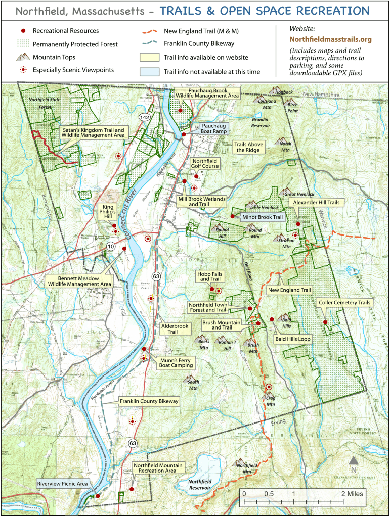
Scroll down for descriptions of the trails organized by their difficulty– Click on trail names for maps and additional information about the trail, parking, and setting.
Least Difficult
Shorter trails with minimal elevation change.
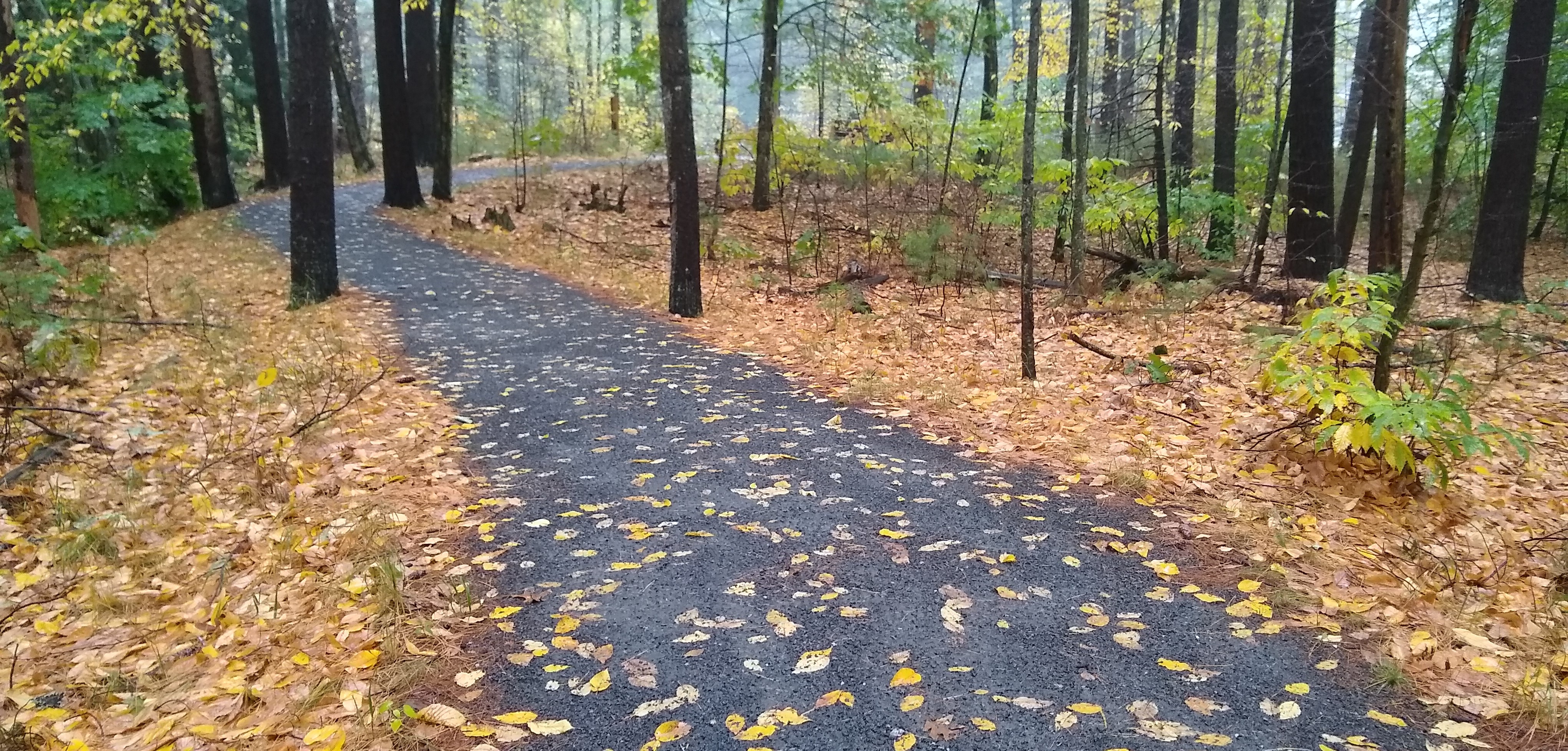
An accessible (wheelchair accessible) trail through a pleasant woods to a beaver pond. Parking area is along east side of route 63 about 1.5 miles south of the village of Northfield; the parking area includes handicapped parking.
- Loop length: 0.5 miles
- Elevation gain: 40 feet
- Substrate: hard-packed fine gravel
A town-owned 46-acre historical and recreation area with a trail to the top of the mountain; the trail is fairly level at the bottom, but the last quarter-mile is a relatively steep gradient to the top of Brush Mtn.
- Loop length: 0.8 miles
- Elevation gain: 220 feet
- Marked with white blazes
A picturesque falls, not far from the road. From the trailhead at the end of the lower part of Old Wendell Rd., follow the road south for 0.4 miles, turn left off the road at the Hobo Falls sign.
- Loop length: 1.1 miles
- Elevation gain: 240 feet
- Northfield Trail Signs
A loop trail on a town-owned historic bluff overlooking the Connecticut River. The trail goes up to the river bank, then stays level until the steep, narrow down at the end; there’s a bench on the way up and another at the top.
- Loop length: 1.5 miles
- Elevation gain: 180 feet
- white blazes
An extensive wetlands and wildlife area, with a circumference trail, on private property near the center of the village. Park at the golf course or library.
- Loop length: 1.5 miles
- Elevation gain: 180 feet
- white blazes
Moderately Difficult Trails
A network of trails for hiking and skiing is located in the Northfield State Forest at the top of Alexander Hill Rd. One of these trails is described here . Check the trail-head kiosk at the top of Alexander Hill Road for information on other trails in this immediate area.
- Loop length: 3.2 miles
- Elevation gain: 280 feet
- mostly blue blazes
A loop off part of the New England Trail. Click on this title or on the “Bald Hills Loop” box in the above map locator for descriptions, trail maps, and directions to the parking area. Start on the white-blazed NET, across the road from the parking area, and soon take the blue-blazed trail to the left. Take a right when the blue trail rejoins the white NET trail to return to the trailhead.
- Loop length: 1.6 miles
- Elevation gain: 360 feet
- blue & white blazes
A network of trails for hiking and skiing is located in the Northfield State Forest off the end of Coller Cemetery Road. One of these trails is described here. Check the trail-head kiosk at the end of Coller Cemetery Road for information on other trails in this immediate area.
- Loop length: 3.1 miles
- Elevation gain: 220 feet
- mostly blue blazes
A town-owned 150-acre conservation and recreation area with a loop trail. Trailhead at the Brush Mountain kiosk and parking area.
- Loop length: 2.2 miles
- Elevation gain: 250 feet
- mostly yellow blazes
More Difficult Trails
A national scenic trail, with an interesting section in Northfield. Sections 16 & 17 are within Northfield.
- Multiple sections of various lengths and various elevation gains
- white blaze
- Official NET Website
One of three substantial trails on a 1300-acre Northfield State Forest property; this is an out/back trail to the top of Notch Mountain.
- out & back: 5.0 miles
- Elevation gain: 800+ feet
- red blazes
One of three substantial trails on a 1300-acre Northfield State Forest property; this is a loop trail.
- Loop length: 4.8 miles
- Elevation gain: ~300 feet
- yellow blazes
A large wildlife management area with a trail on an old forestry road. The trail goes to the top of the ridge, where there is a view of Northfield village across the valley.
- out & back: 3.0 miles
- Elevation gain: ~580 feet
One of three substantial trails on a 1300-acre Northfield State Forest property; this is the interior loop trail.
- Loop length: 3.6 miles
- Elevation gain: ~300 feet
- blue blazes
Hikers are responsible for their own preparation, safety, and enjoyment of the trails. Numerous sources of information are available regarding safe and enjoyable hiking, such as: American Hiking Society.
For GPS apps to track trails on your phone check out: iHike, GPS Tracks, GPS kit, and similar apps.
This website, as well as much on the trails, are courtesy of the Northfield Open Space committee. We request that you use the land and trails respectfully.
